This story begins with a noisy bike chain. I was doing some winter riding down and around Palm Springs when my chain started a creaking. A stop in at the local bike shop resulted, as it often does, in a discussion with the local cycling guru who mentioned the Stagecoach 400.
A minimal amount of recon showed that the route is a 376 miles loop that contains desert, mountain and Pacific Coast Highway riding. The promise of better than Seattle winter weather prompted me to send a text to my co-conspirator Mykenna:
Mike: Stagecoach 400?
Mykenna: Yes!
Good enough for me, let the pseudo planning begin.
A quick look at the route revealed the cool fact that it passes within a mile of my buddy Scott’s house in San Diego. What a perfect start/finish location.
Scott and his partner Brandon joined Mykenna and myself as we rolled out of their driveway at a few minutes past seven on the morning of Sunday December, 17th, 2023. Always up for a spot of adventure Scott and Brandon had decided to join us for the first fifty miles of the trip: San Diego to the small mountain town of Alpine.
We rolled down to the waterfront from Balboa Park and at mile 3.7 I felt the unwelcome tingle of latex spraying my right leg. I stopped to see white liquid bubbling out of a half inch gash. Yep a flat in my brand new never been ridden Rene Herse rear tire, less than fifteen minutes into a five day journey. Mykenna proved his prowess at patching tubeless tires and five minutes and two bacon strips later we were back on the road. The prospect of two desert crossings on a barely passable patch job didn’t seem like an appealing way to start this tour, but oh well what ya gonna do.
The dot gpx file and the printed cue sheet seemed to differ as we neared the Mexican border, but Scott and Brandon assured us that the electronic file was correct, so we turned east towards Chula Vista on a paved bike trail. The trail quickly turned to gravel as we slalomed past pedestrians enjoying a Sunday stroll.
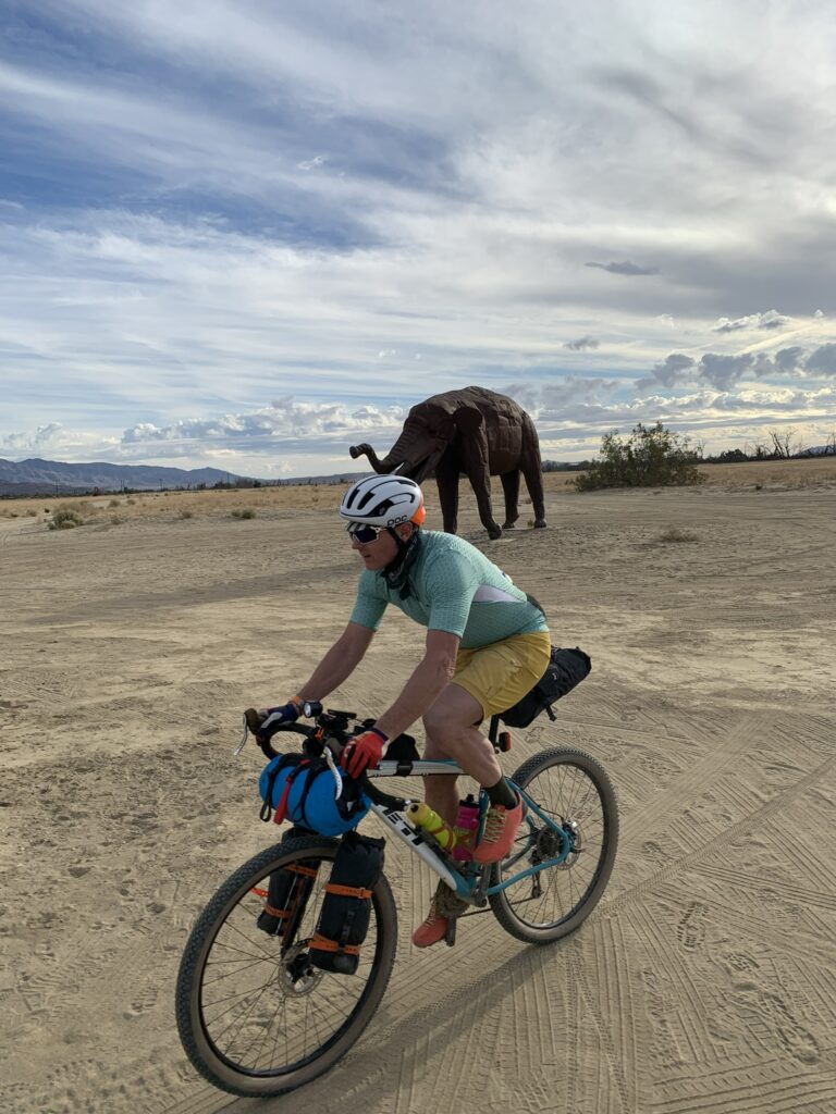
The trail along the Sweetwater Reservoir was legit singletrack where padded mountain bikers gave our loaded rigs (and Scott and Brandon’s urban commuters) a questioning look. As we approached what appeared to be the last grocery store for at least two hundred and fifty miles I decided that my food bags weren’t heavy enough, so we turned off the trail and rolled into the Albertsons.
Back on route we rolled behind a healthy-looking coyote before jumping onto some smooth broad-shouldered pavement. Let the climbing begin.
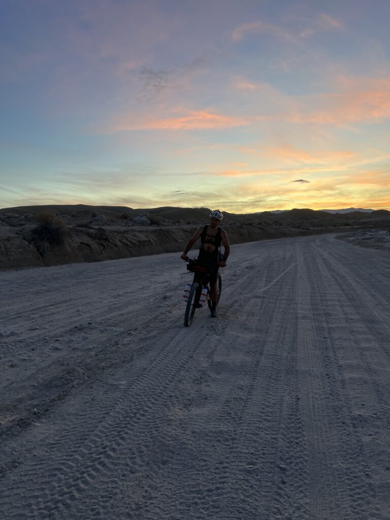
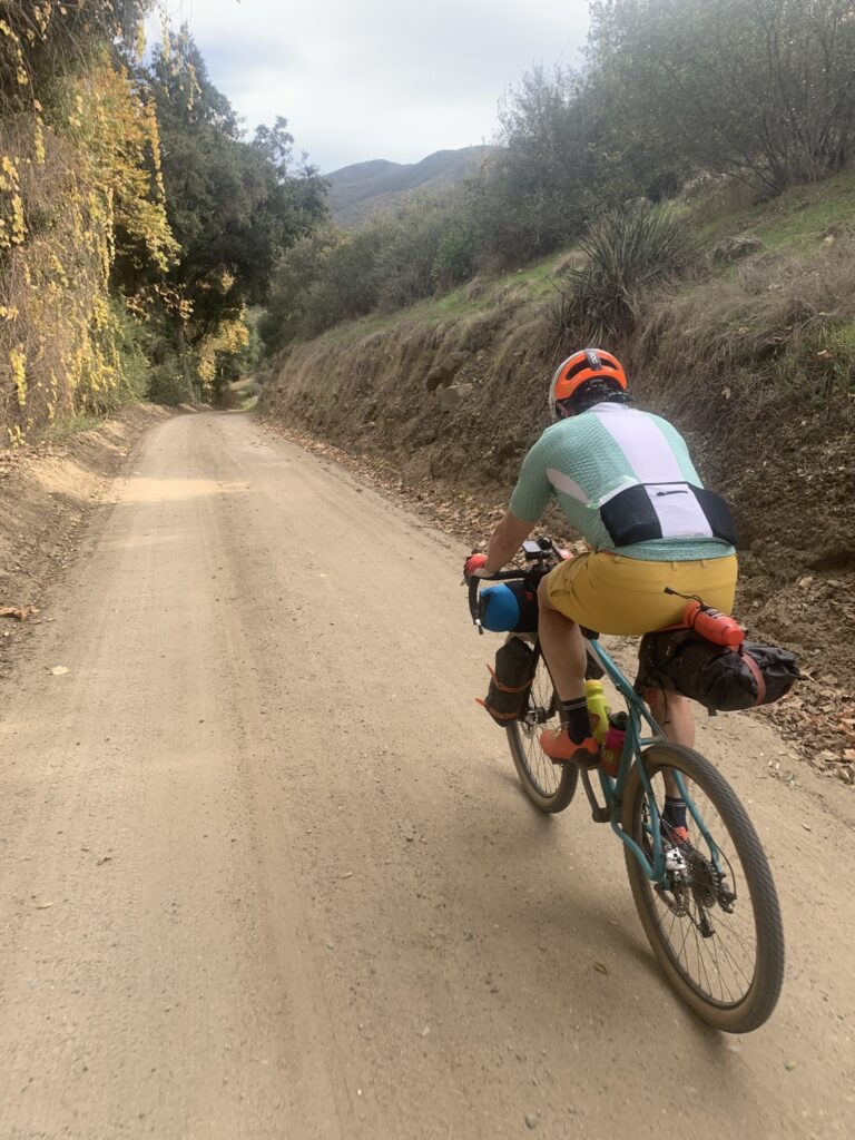
Some nice gravel took us up above the Loveland Reservoir and back onto pavement. We were well into the climb and Scott and Brandon were happy to see their friend Kevin’s Volvo coming the other way. Time to say goodbye to our escorts, Mykenna and I were now a two-man crew. A steady unrelenting climb took us through the town of Alpine, across Interstate 8 and onto the Viejas Reservation. As we passed the Ma Tar Away Campground our future was clear: a brown line of gravel road angling upwards towards a saddle between two distant mountains. It was only midafternoon, but darkness was coming quickly, Mykenna and I simply geared down and started the long climb. The only way to climb a climb is to climb.
We rolled into Oakzanita campground at dusk. Ranger Rick and his blind pup escorted two weary cyclists to a prime spot near, but not too near, the bathroom. A cold darkness comes early near the winter solstice, and despite a desire to sit at the picnic bench and drink tea and talk we retired to our respective micro-shelters at seven and were asleep by half past.
With the exception of a tent dwelling neighbor who screamed expletives all night, the evening was uneventful and restful.
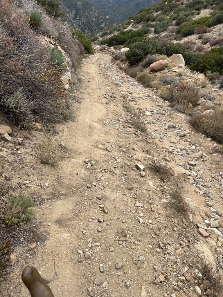
After a breakfast of oatmeal and instant coffee we were peddling up the final fifteen hundred feet to the crest that divides Western and Eastern California. Much of the climbing was on fairly easy singletrack and we made good time to the summit where, according to the cue sheet, there is a place called Pioneer Mail; I passed by without noticing. We had a good zoomer down the other side and just as I was thinking that the descent was going to be a non-event we hit Oraflame Canyon. The “road” descending Oraflame Canyon is a high clearance four-by-four track dotted with hot tub-sized divots and football-sized boulders. Mykenna and I heated up our brake pads as we picked our way through the minefield. Once back on pavement we flew downslope to the Butterfield Store. Finally some hot coffee and maybe a breakfast burrito.
No luck.
The inventory of the Butterfield Store consisted mainly of beer, a few sodas, beer, some candy bars and beer. Worse yet the coffee pot was empty. Damn. I chose to grab a few candy bars in hopes of better things at the upcoming Agua Calliente Store. The guy working the register wore a T-shirt that read
I don’t like morning people.
Or mornings.
Or people.
Welcome to the desert.
A straight stretch of good pavement took us to the Agua Calliente store where Mykenna banged a large gong, made from an old acetylene tank, to signal that customers were afoot. The owner, Mark, is a super cool dude with good knowledge of the SC400, but the shelves of his store were a bit bare. We bought a gallon of water, three Hershey bars and a sleeve of Ritz crackers, which nearly cleaned out Mark’s inventory. Although he didn’t appear to be a cyclist, Mark did seem to be genuinely interested in us and our well-being.
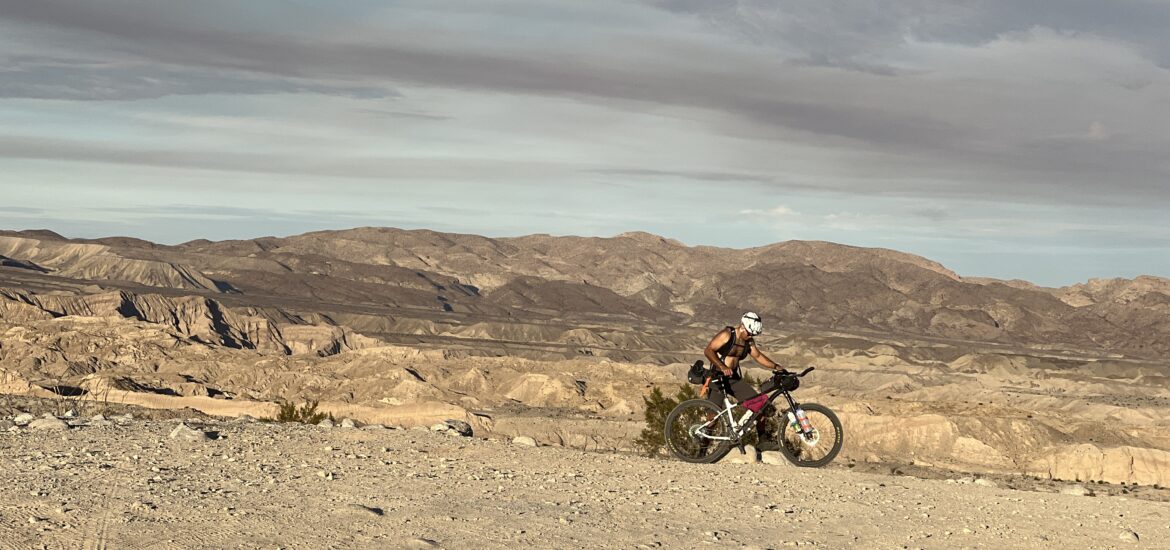
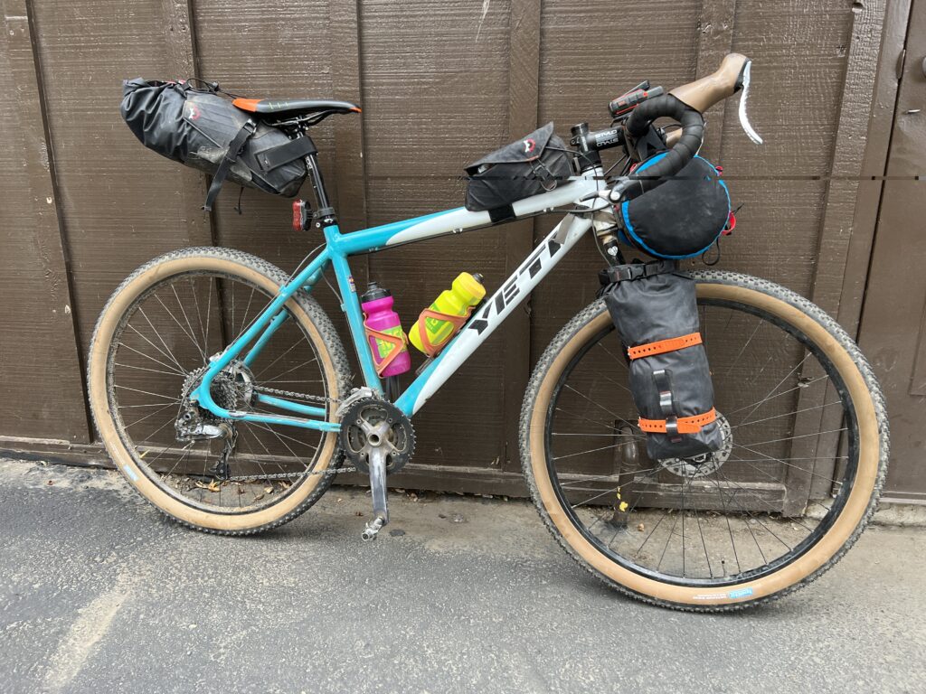
I filled up my two water bottles, a two-liter water bag and the one-liter bottle attached to my filter for a total of five liters. Between his hydration pack and giant fork-mounted bottles Mykenna probably had twice this amount. Okay here it comes twenty-five miles of sand.
I’ve driven this section in my buddy’s lifted FJ, but sitting shotgun in an airconditioned four-by-four and riding it on a fully loaded bicycle are two very different experiences. After the first few miles of beach sand Mykenna hit on a secret: don’t ride where the vehicles have churned up the sand but instead ride on the hardpack off to the side. Wow we were rolling now, this was going to be easy, no problem.
Wrong.
The solid stuff became increasingly scarce and within a mile we were back to tire deep beach sand. I was riding fifty-two millimeter tires, Mykenna a bit wider, and it wasn’t great, but it was rideable. Occasionally, a boss hogg rig would pass by; all of the overlanders kept the dust down, and a few even threw us a thumbs up. Diablo Drop was an interesting wall of potholes and silt, Mykenna managed to ride it while I carefully picked my way down on foot.
The dark came quickly and for some reason my SON hub generator-powered headlight flickered and then faded to black. Mykenna rode behind me guiding me by the beam of his headlight. After some jarring washboard we hit the pavement, hallelujah we were out.
A quick ride took us to the town of Ocotillo Wells. Well I guess it’s a town. Seemingly the only business is the Iron Door Saloon. The cue sheet said that the place is welcoming to SC400 riders, and that frozen pizza might be available. After a bit of discussion, Mykenna and I decided to skip the Iron Door and push on another twenty miles to Borrego Springs.
The first ten miles up the highway was deceptively uphill, but once we turned right towards Borrego Springs life got easier, except for one steep rise, and soon we were riding around Christmas Circle looking for the famed Jilbertos restaurant, hoping that it would still be open.
Luckily, we arrived ten minutes before closing time. Burritos and fries for everyone! The burritos at Jilbertos are fantastic and I’m not saying that because I’d only eaten candy bars, dehydrated chicken and dumplings and oatmeal for the past thirty-six hours. The place is great and the reputation well-deserved.
Mykenna booked us a room at a fifties-era motel; it was good enough despite the fact that the door didn’t close, and the door handle tended to fall off in your hand, but other than that…
The next morning we returned to Jilbertos for huevos rancheros and breakfast burritos. While munching down our massive breakfasts a fit-looking sunbaked dude came in and introduced himself as Rick. Rick Rethoret to be exact, a friend of SC400 riders and the source of some good information regarding our upcoming trial by fire up Coyote Canyon. Rick seemed to relish the fact that neither Mykenna nor I knew what we were about to get ourselves into.
We left Borrego Springs with trepidation.
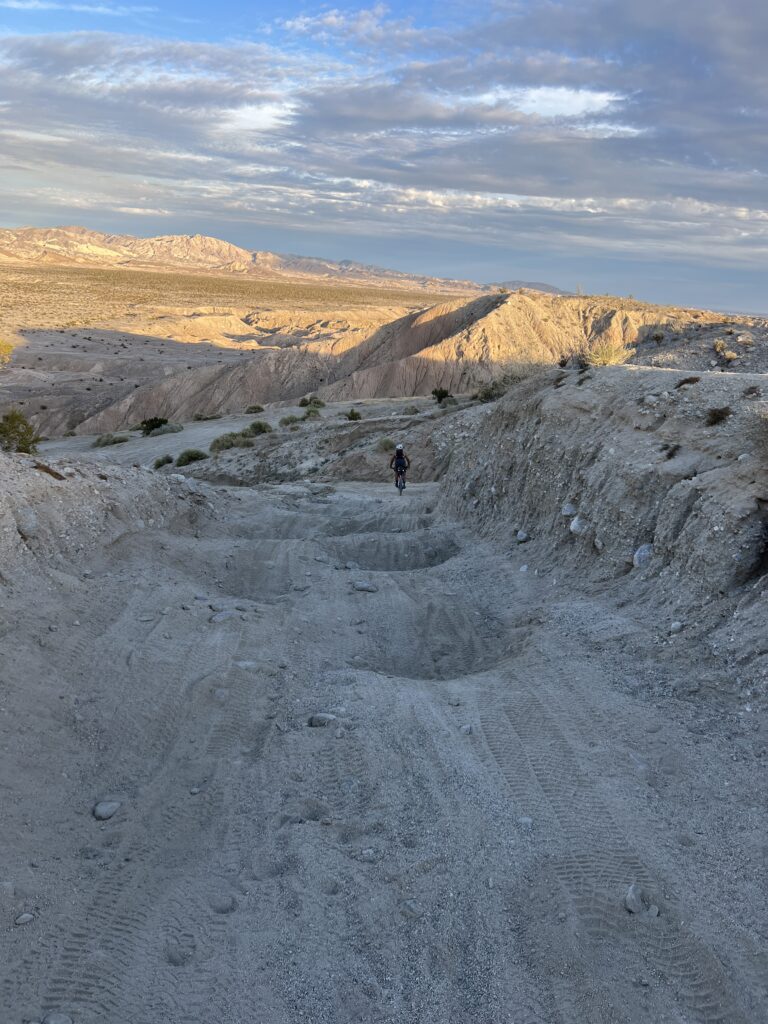
Okay here we go, off the pavement and onto the sand. The cue sheet read, “Pavement ends. Sand begins. Life is questionable. Dig deep.” At first the riding was okay, slow, but we were moving forward. The weather was good: sunny but not hot. Soon enough we reached the end of the drivable section, cue sheet said, “route gets very Western for a while.”
“What do you think it means by “Western”” Mykenna asked as we pushed our bikes up a rocky slope.
“I don’t know, but I’m definitely questioning life right about now.” I responded.
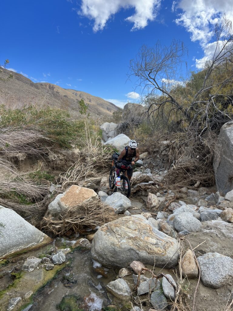
Conditions degraded at an unsettling pace, and soon there was more pushing than riding. I was beginning to run low on water when we arrived at a small stream that led to a desert oasis called the Willows.
The trees, willows I guess, that line the creek are between two and three inches in diameter and are impenetrable with a bicycle. Our only option was to climb directly up the streambed. This required lifting our loaded bikes up a series of boulder-strewn waterfalls. Under normal circumstances a trip though the Willows would have been an exotic experience as it’s a green oasis in the middle of an arid brown desert – like a Bedouin hideout – but pushing/carrying loaded bikes up the rocky creek bed rubbed the wow factor off right fast.
The riding after the Willows was fairly okay and I was just beginning to think we were on easy street when the real soft stuff began. At this point we surrendered and became pedestrians.
Prior to our departure I’d read several route descriptions and nowhere did I find mention of five miles of walking through deep sand. The sun was getting low in the western sky, and we were in the middle of nowhere pushing forty-pound bikes. It would have been easy to kind of freak out here, but I had Mykenna, I had water, I had food, I had camping gear, okay no problem, head down move forward.
Finally, we pushed our way up a hill and towards a cluster of homes. “Don’t trespass,” we had been warned, “those guys are all crazy pot growers.”
We were on something that kind of resembled a road when a nice retired couple rolled up in a newish pick-up. The guy was looking a bit scraggly but his wife was neat as a pin; they wanted to talk about animal tracks. It was getting dark when we hit the pavement that would take us to the Sunshine Market.
The Sunshine Market is in the Sunshine Mobile Home Park, near, but not near enough, to the town of Anza California. I wouldn’t say that the Sunshine Market was falling down, but it wasn’t standing up either. Kind of leaning I guess. The inventory was slim, but Mrs. Singh was gracious and said that we could either rent an unused trailer or camp in the “playground” next to the store. We had camping gear and obviously chose to camp.
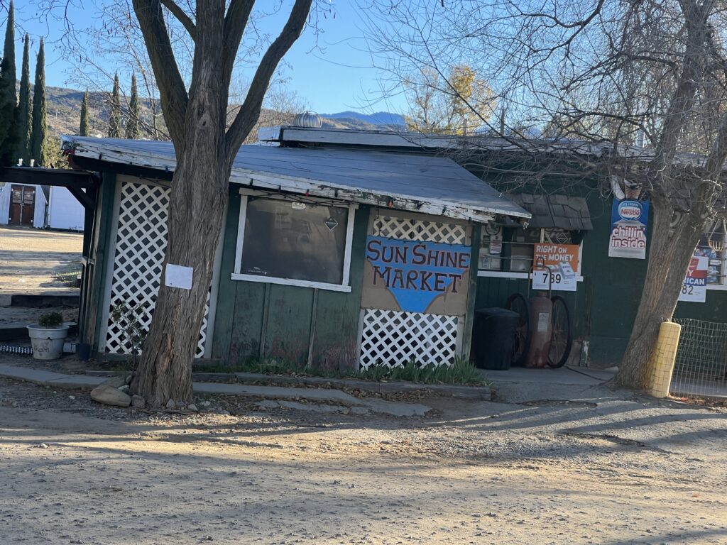
I unloaded my bike and just before setting up my tent I took a walk over to the public bathroom. I came back and said “Mrs. Singh we’ll take the trailer.” And that’s all I’m going to say about that.
While a dude named Billy, who was hanging about the store, helped Mykenna unlock the trailer I waited while Mrs. Singh filled a box with two aluminum cooking pots and four glasses. “Don’t leave the place dirty,” she said handing me the kitchen wares.
The only furniture in the trailer was a small kitchen table, but the stove was operational, so we rehydrated our food, aired up our pads, rolled out our sleeping bags and settled in for the night.
Everyone we had met over the past one hundred and fifty miles had warned us of an impending maelstrom complete with torrential rains and flash flooding, it sounded downright biblical. We woke up the next morning to crystal blue skies.
From Anza the SC400 route does a loop up to Idlywood and back. Because we’d only made a little over thirty miles the day before, Mykenna and I didn’t have the time for the loop so we headed for what we thought should be a downhill slide to the ocean. Odd how you can start in the mountains at four thousand feet and ride to the Pacific Coast but have to climb seven thousand feet to do it. Odd but true.
Not a creature was stirring at the Sunshine Mobile Home Park as Mykenna and I rolled out and onto the highway. A few miles of downhill tarmac took us to a dirt road that, while a bit sandy, was fairly decent riding. My legs were feeling good as we rolled along with the morning sun at our backs. The road quickly deteriorated but it was ridable; our plan was to spend the night in Encinitas at a friend’s house, it looked to be a good day.
A series of undulating climbs and then a paved descent dropped us off on Highway 79, just two miles to the Warner Springs Gas Station. The small climb to Warner Springs seemed unusually steep, maybe we had a headwind, whatever the reason I arrived at the gas station a bit gassed. In keeping with the theme of this ride the Warner Springs gas station had slim pickings. As I was checking out I noticed a refrigerator containing what appeared to be sandwiches behind a plastic chain.
“Could I heat up something from that fridge,” I asked the lady behind the counter.
“I have a jalapeno dog heated up, if you want that,” she replied.
Heck yeah I wanted the jalapeno dog. I also bought three candy bars, a bag of pickles, a can of Pepsi, a bottle of cranberry juice and half a gallon of water. I ate it all while sitting at a picnic bench behind the dumpster. Mykenna ate an armful of groceries as well. Things were looking up.
After fighting headwinds along Highway 79 we turned right near Lake Henshaw and then left up the incredibly steep Mesa Grande Road. This climb looks innocuous on the route profile but it’s a real killer.
A short descent and then some ups and downs on rough double track dropped us onto glorious descent down Black Canyon. A bit of Crest to Coast singletrack took us to pavement and then came the right turn onto highway 78. The only word that I can think of to describe this section of road is sketch. Super sketch. It’s a paved descent and Mykenna and I were hitting speeds in excess of thirty miles per hour, but we were continually being passed by cars, pickups and tractor trailers going twice, some even three times, that speed.
Our death ride down Highway 78 ended at a turn onto some single track that took us to the bright lights of Escondido. We pulled into a McDonalds where I ordered five hamburgers, a large fry and a medium root beer.
“You gonna eat all that?” Mykenna asked looking at the pile of burgers.
“I sure am,” I replied: and I did.
A quick look at the map showed us within a snowball’s throw of the Pacific Coast Highway; Encinitas here we come. Little did I know we were entering a black hole. A place devoid of light in the middle of urban sprawl. A place where one could ride for an hour and get neither closer nor further away from anything. We rode and we rode and we rode some more and we seemingly made almost no forward progress. When we arrived at what the cue sheet calls “switchback city” I was beginning to doubt my sanity. Was I dreaming?
Our friends in Encinitas, Bill and Beth, are in their seventies and finally I had to text Beth to tell her that we’ve entered some twilight zone where time and space are not linear, and that no way were we going to make it their house before midnight. Mykenna and I would have to find a hotel once we found the exit portal.
The portal is known locally as Jimmy Durante Road.
Finally, we arrived in Del Mar where the main street was all dressed for Christmas. We turned south on the Pacific Coast Highway and pulled into the first hotel: The Hotel Del Mar. Wow this place looks pretty fancy, I thought to myself as we circled the complex looking for the front door. When it comes to finding a place to lay my head at midnight on a bikepacking tour I’m not going to penny pinch. Mykenna is of the same mind, and soon we were showered and in a comfortable bed.
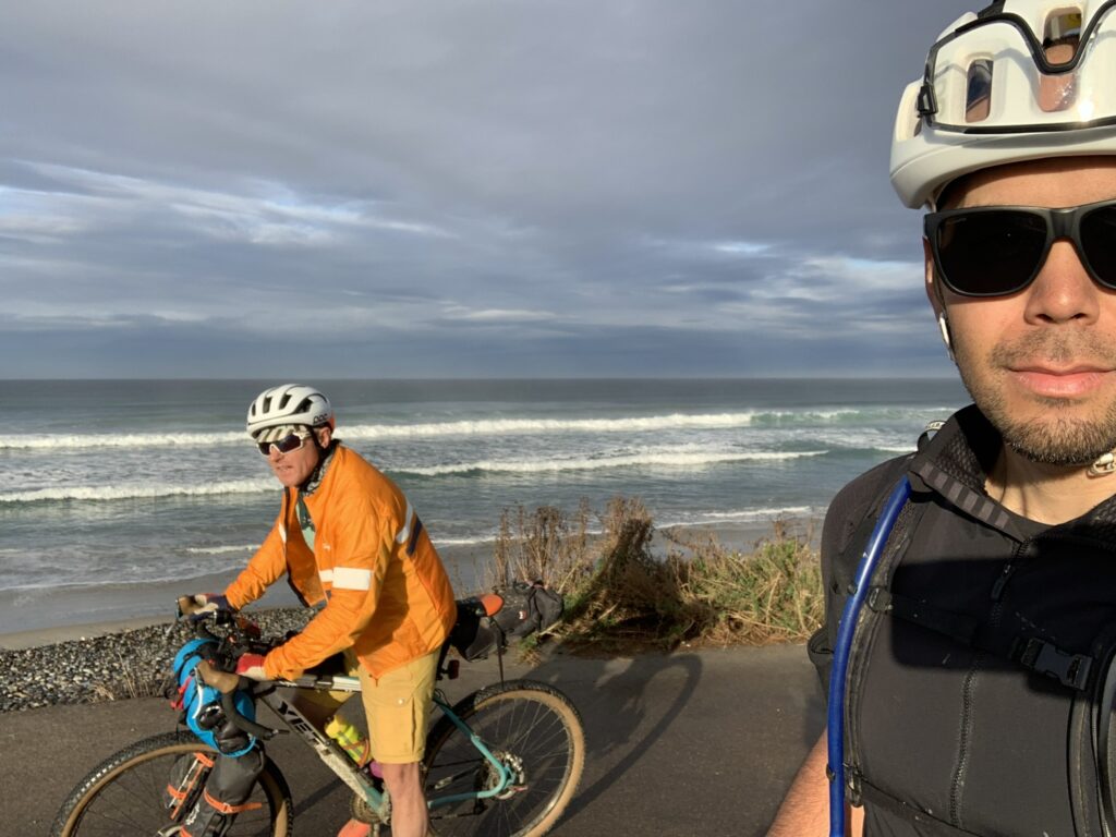
I love this coastal area north of San Diego, the weather is great and the vibe laid back. The next morning the air was thick, fragrant and warm as we rolled out onto the PCH. Our plan was to grab breakfast at the first eat’n place we passed.
We passed no restaurants as we descended to the coast. I ate a handful of gummy works as we climbed a steady grade towards UC San Diego. A bit of creative single track and then some difficult route finding took us around Mission Bay and then to Mission Beach where we stopped at the first food place we encountered.
After breakfast I called Scott who agreed to meet us at the Maritime Museum where he’d show us the way back to his house. After a bit of off-route wandering through the city we got back on course and after some easy riding along the waterfront we arrived at the Maritime Museum.
I was worried that the climb up to Scott’s house would be a sting in the tail, but the grade was gradual and the road super safe due to a delineated bike lane. It was an easy final day that put us back where we started, now it was time to shower, pack, eat a big lunch and get Mykenna to the airport.